Loading
by BlastRoom
Read station data, surface maps and air mass source regions to work out what an approaching front will bring.
#us_grade_8_science
40 questions
One question set, multiple game modes. Tap any game to see it in action. Not sure which to pick?
Answer to place stones and capture territory.
Outrun the snow together.
Earn blasts, then hunt the other team.
Answer to earn energy, then climb.

The class blasts through walls together.
Bid on mystery lots. Most money wins.
Sell tours. Nice, standard, or a total scam.

Answer, restock, and serve the rush.
More correct answers pulls the rope your way.
Answer, then shoot down the alien wave.
Answer, then tap to leap the frozen ridge.
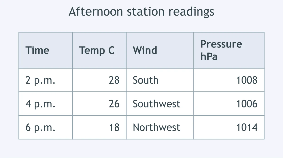
The table shows one station's readings through the afternoon. Which boundary passed over the station between 2 p.m. and 6 p.m.?
Over six hours a station's temperature rises from 4 C to 13 C, its wind shifts from east to southwest, and hours of light steady rain end. Which boundary passed?
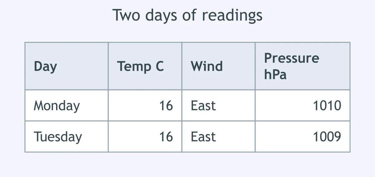
A station reported these values on two straight days while low cloud and light rain continued. Which boundary lay across the region?
Near the center of a deep low, a station has rain both before and after its temperature falls 6 C, and its wind turns from southeast through south to west. Which boundary passed?
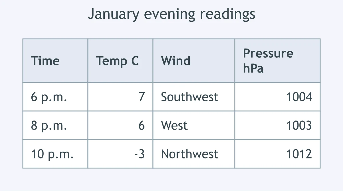
The table gives evening readings at a station in January. What moved through the station during the evening?
A station's pressure falls slowly, thin cirrus thickens into low gray stratus, drizzle begins, the temperature creeps up and the wind swings from northeast to south. Which boundary is passing?
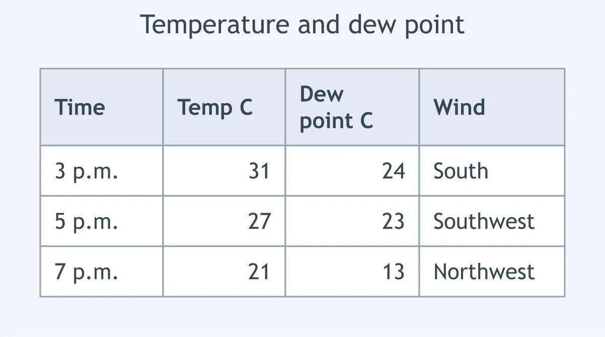
The table shows readings at a station where a line of thunderstorms hit at 5 p.m. Which boundary produced the change?
For three days a town near a boundary has had cloud, light rain and almost no temperature change. North of the boundary the wind blows from the east, and south of it from the west. Which boundary is this?
A purple line on a weather map has triangles and half circles on the same side of it, all pointing east. What does the line show?
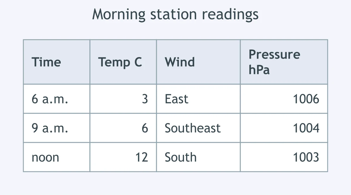
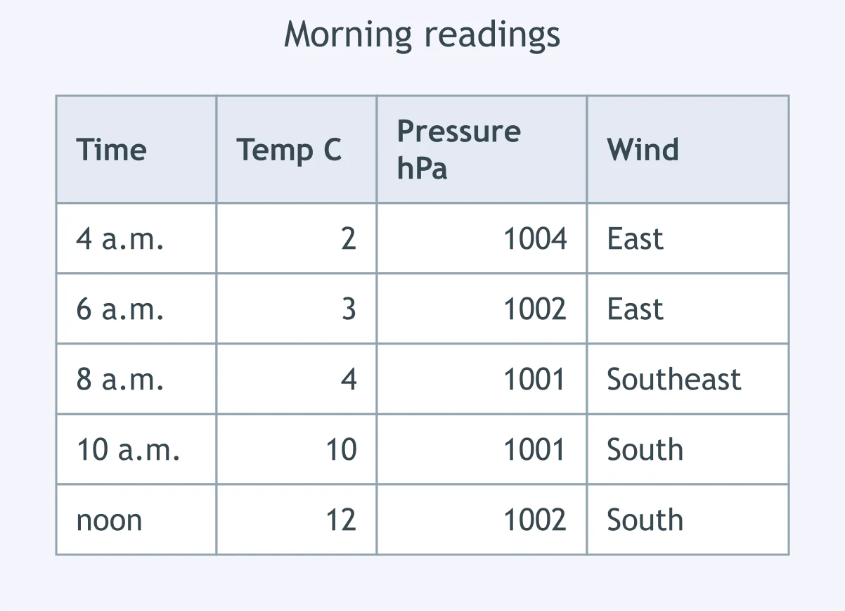
The table gives one station's readings through the morning. Which boundary crossed the station?
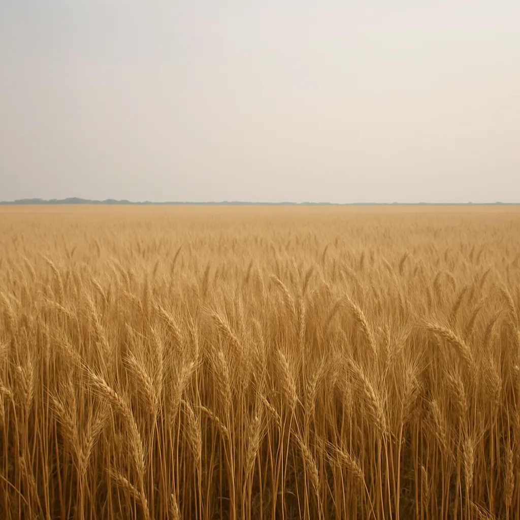
Cool dry air is sliding southeast toward a town where the air is warm and very humid, and its leading edge arrives tonight. What will the next twelve hours most likely bring?
Warm humid air is riding up over a wedge of cold air east of a city, and the boundary reaches the city overnight. What weather should the forecast call for first?
A cold front will sweep across a station tonight. How will the station's barometer behave through the passage?
Cirrus clouds appear in the west and thicken and lower all day as a warm front approaches a station. What follows this cloud sequence?
A front has stalled along a valley and the steering winds aloft are weak. What should the valley's forecast say for the next few days?
Near a deepening low, a cold front has caught up with the warm front ahead of it, and the joined boundary is moving toward a city. What will the city get?
In January, cold dry air from central Canada is racing south toward a city where it is 6 C with a south wind. What is the most likely twelve-hour sequence?
A Gulf Coast station reports a dew point of 24 C, and a cold front is due to pass at midnight. What should the forecast say about humidity after midnight?
A hurricane is forecast to reach a low-lying coastal town at high tide tonight. Besides heavy rain and strong wind, what is the greatest danger to the town?
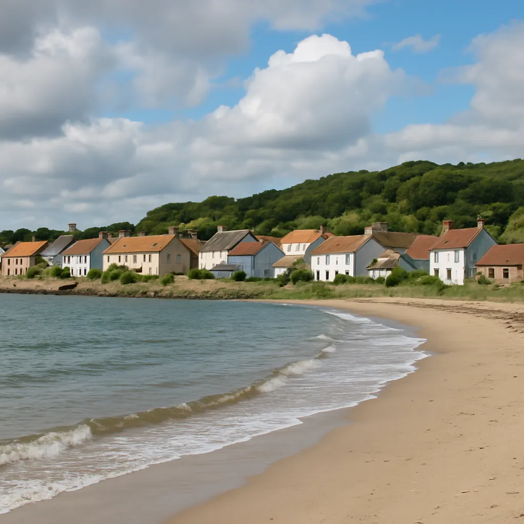
A cold front cleared a town this afternoon and a large high pressure center is building in behind it. What weather will tonight and tomorrow bring?
An air mass sits for ten days over the interior of Alaska and the Yukon in midwinter, then moves south into Montana. What properties does it bring?
Air stagnates over the Gulf of Mexico for a week in July before drifting north into Louisiana. What properties does that air mass carry with it?
An air mass forms over the cold North Pacific off the Alaskan coast and then moves onshore into Oregon. What properties does it have when it arrives?
In June an air mass rests over the deserts of Arizona and northern Mexico before spreading east into Texas. What properties does it bring to Texas?
An air mass forms over the ice covered Arctic Ocean north of Canada in February and then plunges south into the Dakotas. What properties does it carry?
An air mass forms over the chilly North Atlantic near Newfoundland and then blows southwest into New England. What properties reach New England?
A summer air mass reaches Georgia at 32 C with a dew point of 24 C. Which source region did that air mass most likely come from?
An air mass arrives over Oklahoma at 35 C with a dew point of only 5 C. Where did this air mass most likely form?
On a surface map the isobars are packed tightly over Kansas and spread far apart over Ohio. What does this pattern tell a forecaster?
A surface map shows a low pressure center over Iowa. In the Northern Hemisphere, how does surface air move around such a center?
A surface map shows a large high pressure center over Nevada with widely spaced isobars. What weather does that part of the map have?
A map shows a blue line drawn through Missouri with solid triangles along it pointing southeast. What does that line show?
A map shows a red line across Ohio with solid half circles along it pointing north. How should a forecaster read this line?
One boundary on a weather map has blue triangles along its north side and red half circles along its south side. What does that symbol mean?
A surface map shows a city sitting between a warm front to its east and a cold front to its west, both moving east. What air is over the city right now?
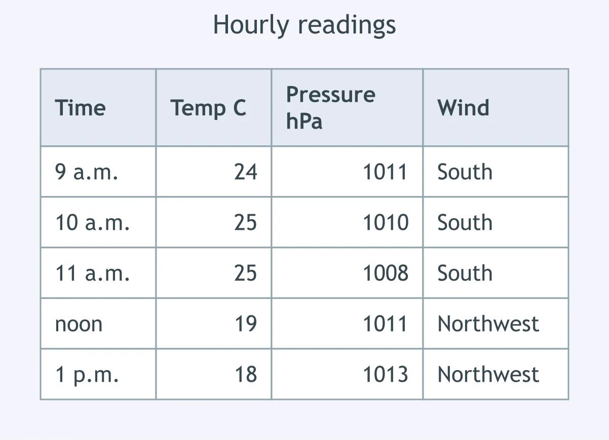
Use the station's hourly readings in the table. Between which two readings did the front pass?
A station reads 13 C with a south wind at 3 p.m. and at 4 p.m., then 7 C with a northwest wind at 5 p.m. and 6 C at 6 p.m. When did the front pass?
Read the overnight table. In which hour did the cold front cross the station?
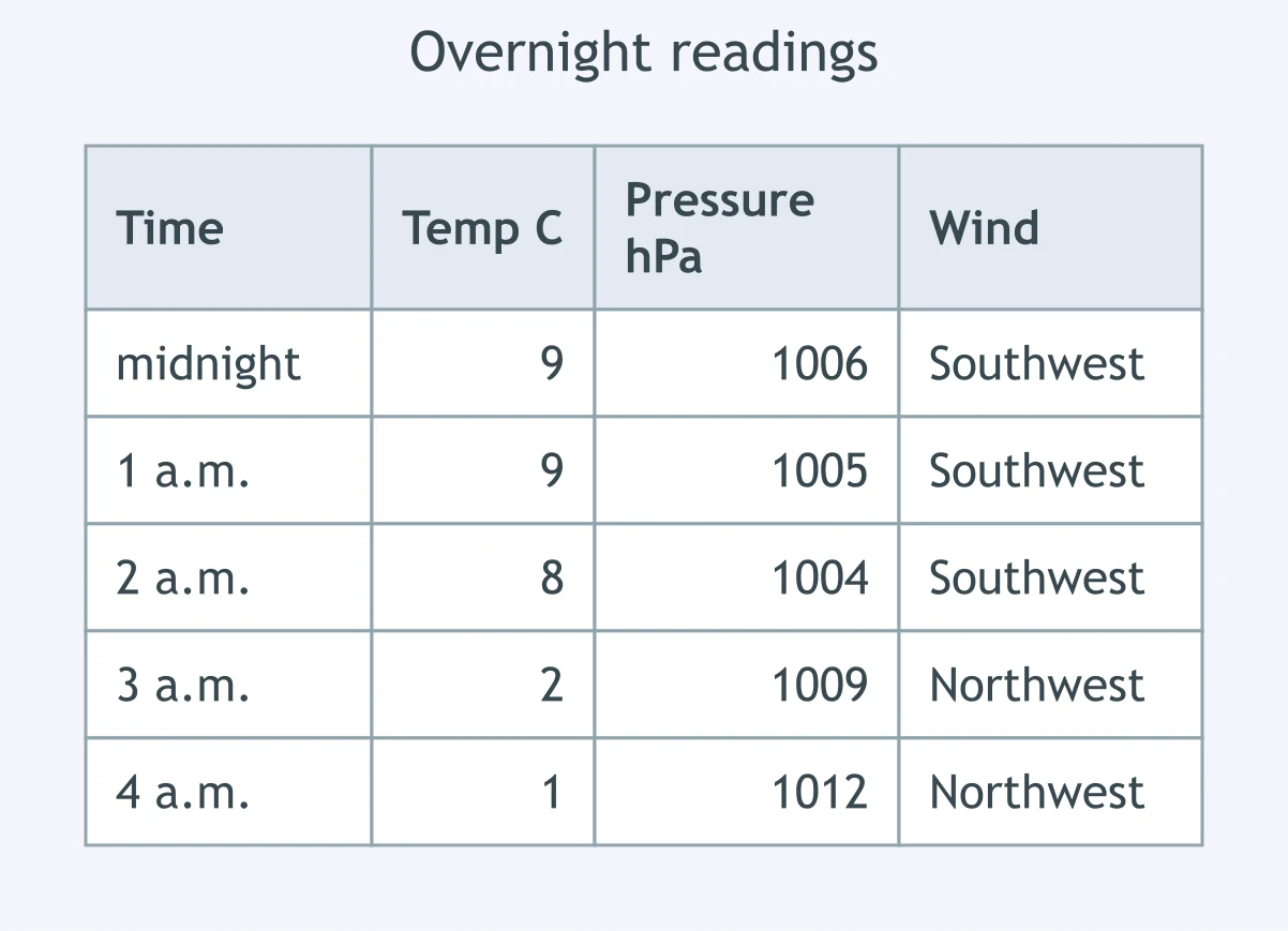
The table gives a station's morning readings. Between which two readings did the warm front pass?
A ship's barometer reads 1004 hPa at 6 a.m., 998 hPa at 8 a.m., 991 hPa at 10 a.m., 996 hPa at noon and 1003 hPa at 2 p.m. When was the storm center closest?
Crack the passcode before the zombies get in.
Answer, then swat bugs for bonus points.
Race through questions at your own speed.
Same question on every screen. Fastest wins.

Pick a tile, answer, hit bonuses and steals.
Ocean Currents and Climate
40 questions