Loading
by BlastRoom
Read a passive-margin profile and a bathymetric map to identify sea floor features and explain how each one formed.
#earth_space_science
40 questions
One question set, multiple game modes. Tap any game to see it in action. Not sure which to pick?
Answer to place stones and capture territory.
Outrun the snow together.
Earn blasts, then hunt the other team.
Answer to earn energy, then climb.

The class blasts through walls together.
Bid on mystery lots. Most money wins.
Sell tours. Nice, standard, or a total scam.

Answer, restock, and serve the rush.
More correct answers pulls the rope your way.
Answer, then shoot down the alien wave.
Answer, then tap to leap the frozen ridge.
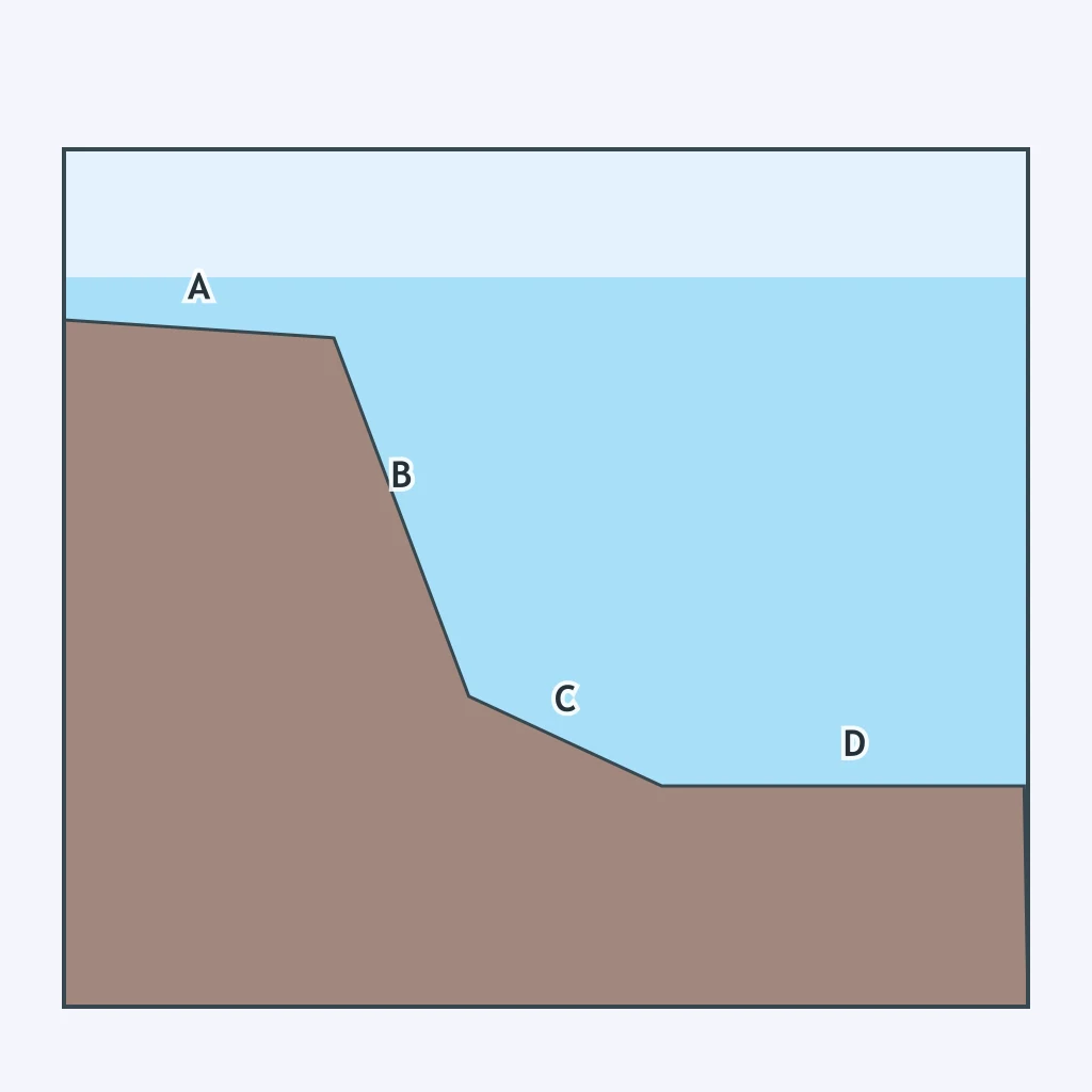
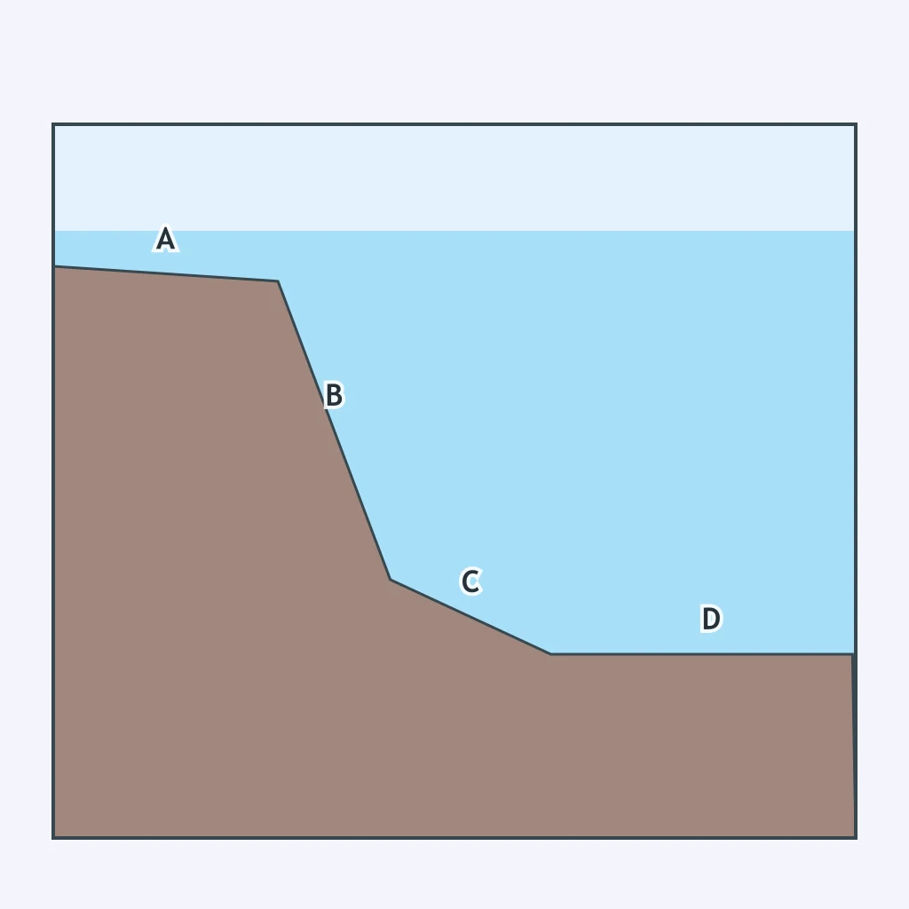
In the profile below, letter A marks the section closest to shore, where the water is shallow and the sea floor is nearly flat before a steep drop begins. What feature is at A?
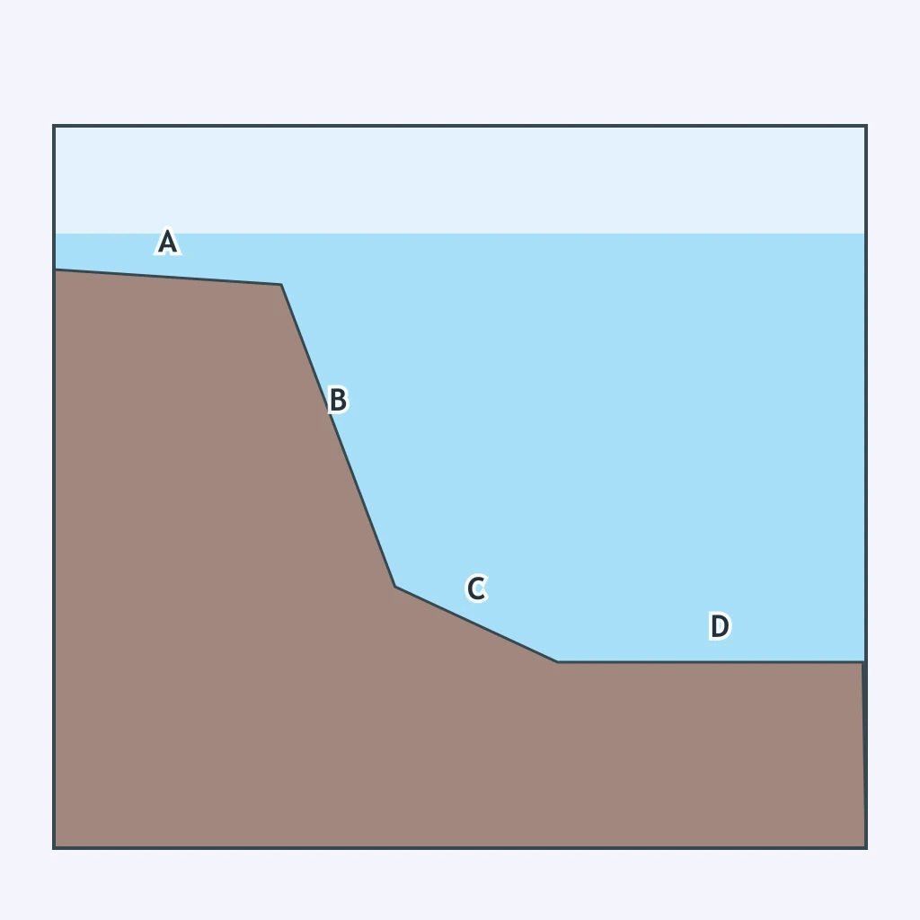
Letter B in the profile below marks the steepest part of the sea floor, where depth increases quickly over a short horizontal distance. What feature is at B?
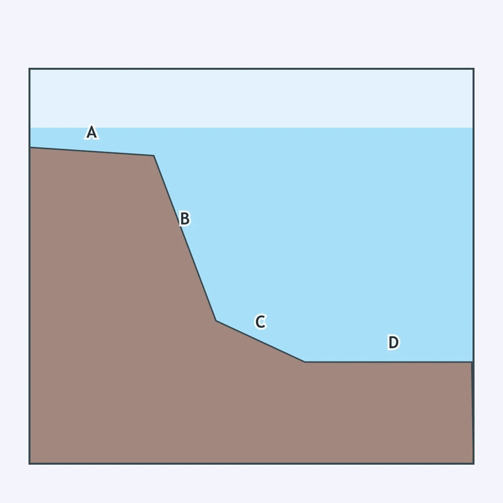
Letter C marks the part of the profile below where the steep drop has eased into a gentler, longer slope before the sea floor flattens out. What feature is at C?
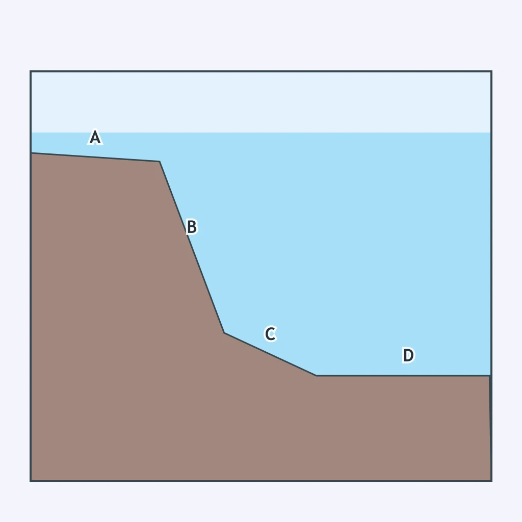
Letter D marks the flat, deep section of the profile below, far from shore, where the sea floor has leveled out completely. What feature is at D?
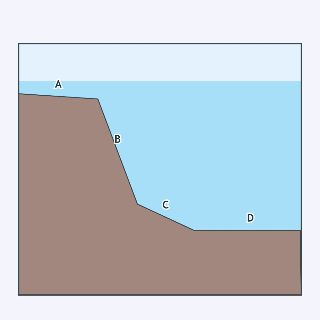
A ship sails from the beach out across the profile below, toward the open ocean. At which lettered point does the sea floor first drop sharply?
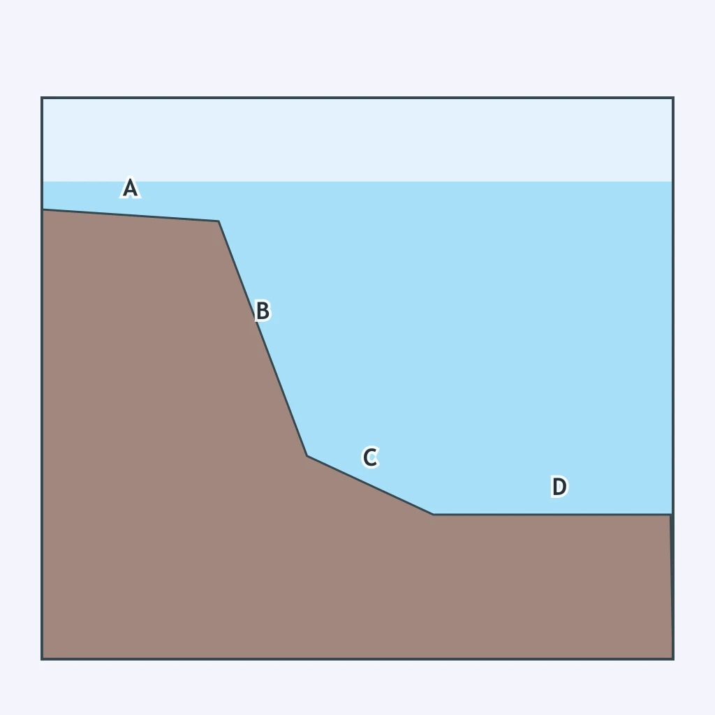
Which lettered point in the profile below lies on the gently sloping apron of sediment that has washed down from the slope above it?
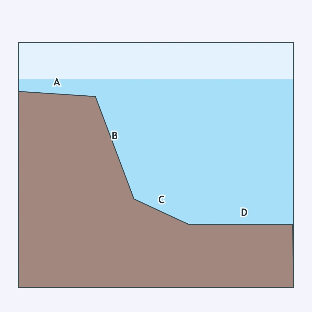
A cable is laid from the beach out across the profile below. At which lettered point is the water shallowest?
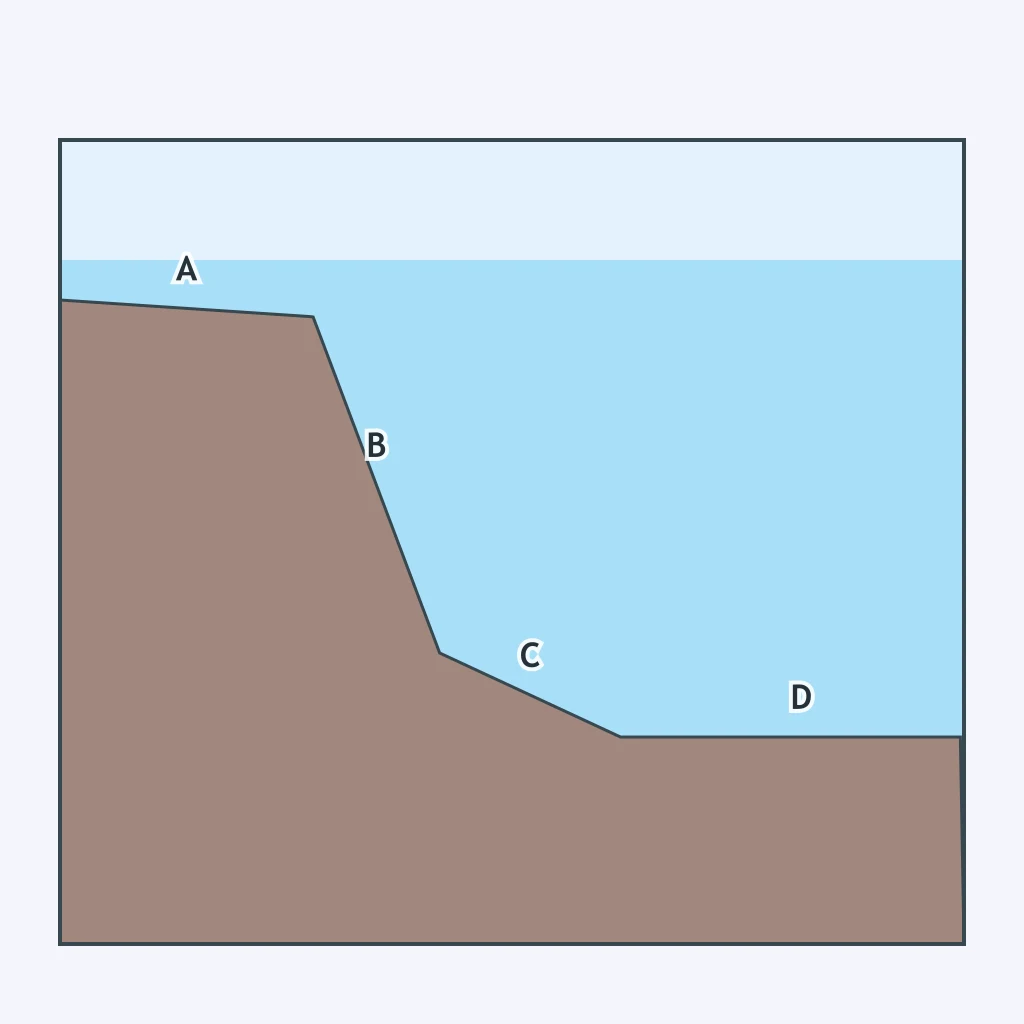
Which lettered point in the profile below lies at the greatest average water depth?
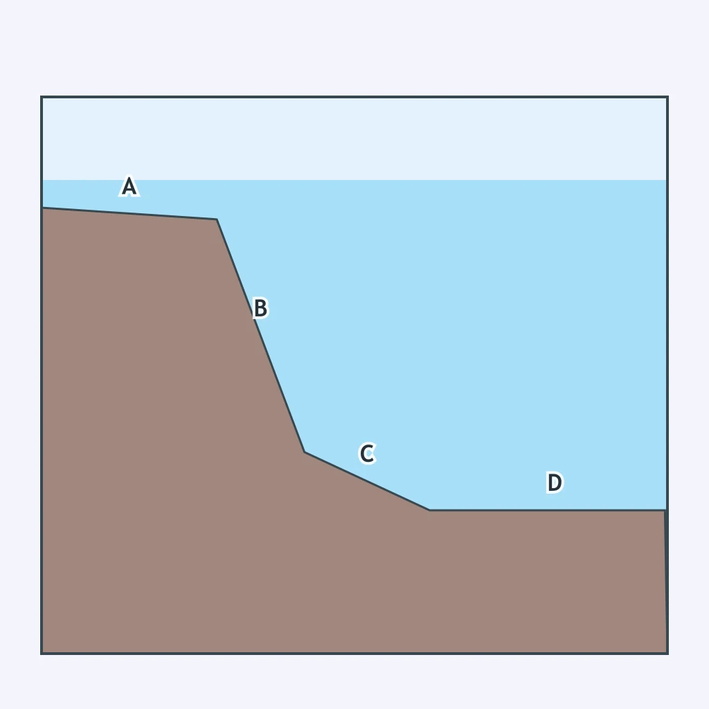
Which two lettered points in the profile below lie on the two flattest sections of the sea floor?
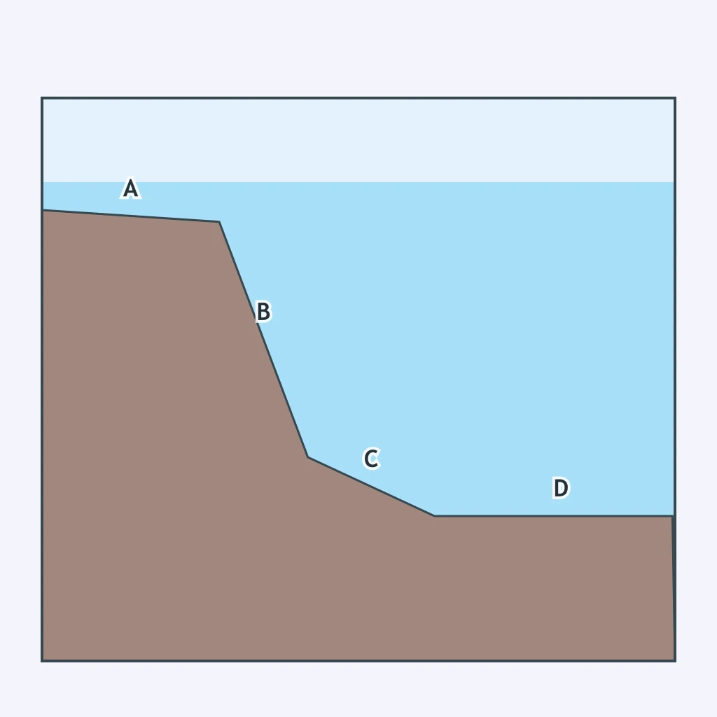
The profile below runs from a beach out into the open ocean with no plate boundary anywhere along it. What type of margin does this profile show?
The lowest point on the entire ocean floor lies about 10,935 meters below sea level in the western Pacific, inside a long, narrow depression beside a curving chain of volcanic islands. What feature is this?
A continuous underwater mountain range winds through every major ocean basin for roughly 65,000 kilometers, its highest points split by a narrow central valley where new crust forms. What feature is this?
A shallow, gently sloping strip of sea floor extends from the shoreline out to a water depth of only about 150 meters before the ocean floor begins to drop away quickly. What feature is this?
Just beyond the shelf edge, the sea floor plunges from around 150 meters to several thousand meters over a fairly short horizontal distance, far steeper than anything landward of it. What feature is this?
Far from any coastline, a vast stretch of sea floor lies almost perfectly flat and level, buried under a thick, even blanket of fine sediment thousands of meters below the surface. What feature is this?
An isolated, cone-shaped underwater mountain rises more than 1,000 meters above the surrounding sea floor from an extinct volcano, without ever reaching the surface. What feature is this?
A submerged, flat-topped volcanic peak rises from the Pacific abyssal floor, its level summit lying about 1,500 meters below sea level. What feature is this?
A steep, V-shaped channel cuts across the continental shelf and slope, carved into the sea floor much like a river valley on land. What feature is this?
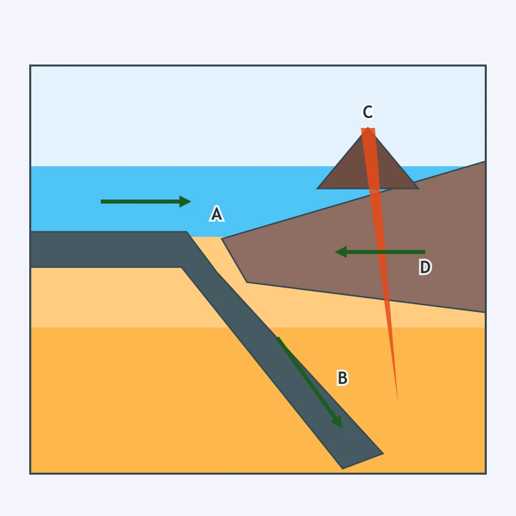
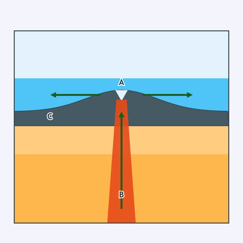
In the cross section below, point A marks a deep notch in the sea floor. How does this feature form?
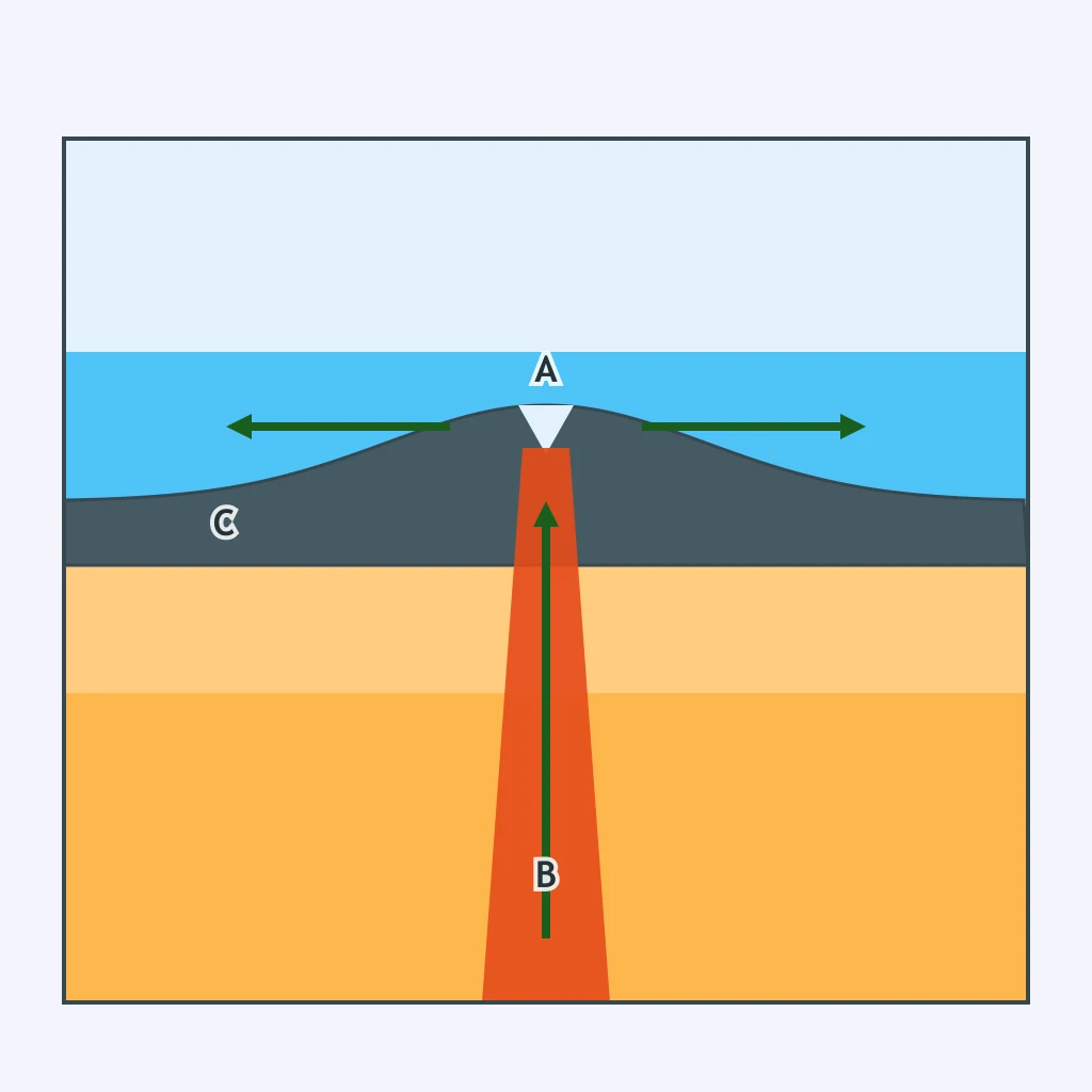
Point B in the cross section below marks molten rock rising into the central rift of an underwater mountain range. What is happening here to build new sea floor?
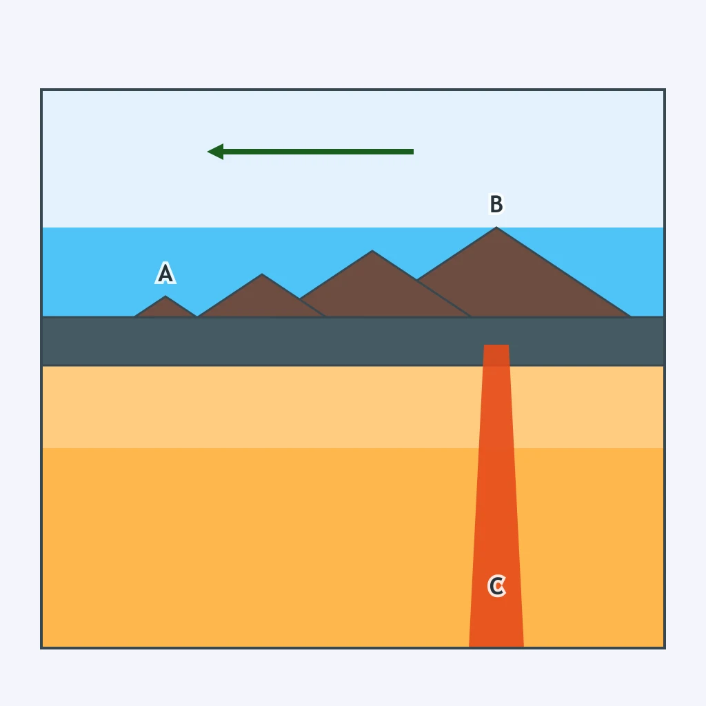
Point A in the cross section below marks the island in the chain that lies farthest from the column of rising magma beneath the chain. Why is this island the oldest?
Point D in the profile below marks the abyssal plain, the flattest section of the whole profile. Why is the sea floor so level there?
A chain of extinct volcanic peaks rises from the Pacific abyssal floor, and each peak is capped by a flat, level surface about 1,700 meters below sea level. How did those flat tops most likely form?
A long, narrow ridge of sand runs parallel to the coast, separated from the mainland by a shallow lagoon. How did this landform most likely form?
A steep, V-shaped channel is cut into the continental shelf and slope, extending far out onto the sea floor beyond the shelf edge. What process most likely carved this feature?
Near the Galapagos Rift in 1977, the submersible Alvin found chimney-like structures where seawater seeping into cracks is heated by magma and gushes out charged with dissolved minerals. What feature was this?
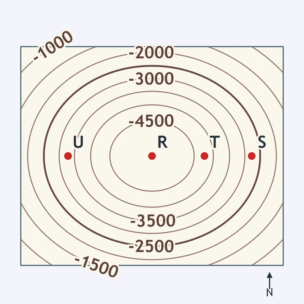
The bathymetric map below is contoured every 500 meters. Reading the contour lines, which of the four labeled stations sits at the shallowest depth?
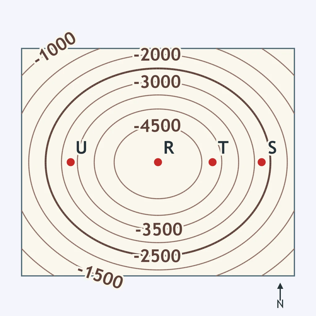
Using the same contoured bathymetric map below, which of the four labeled stations sits at the greatest depth?
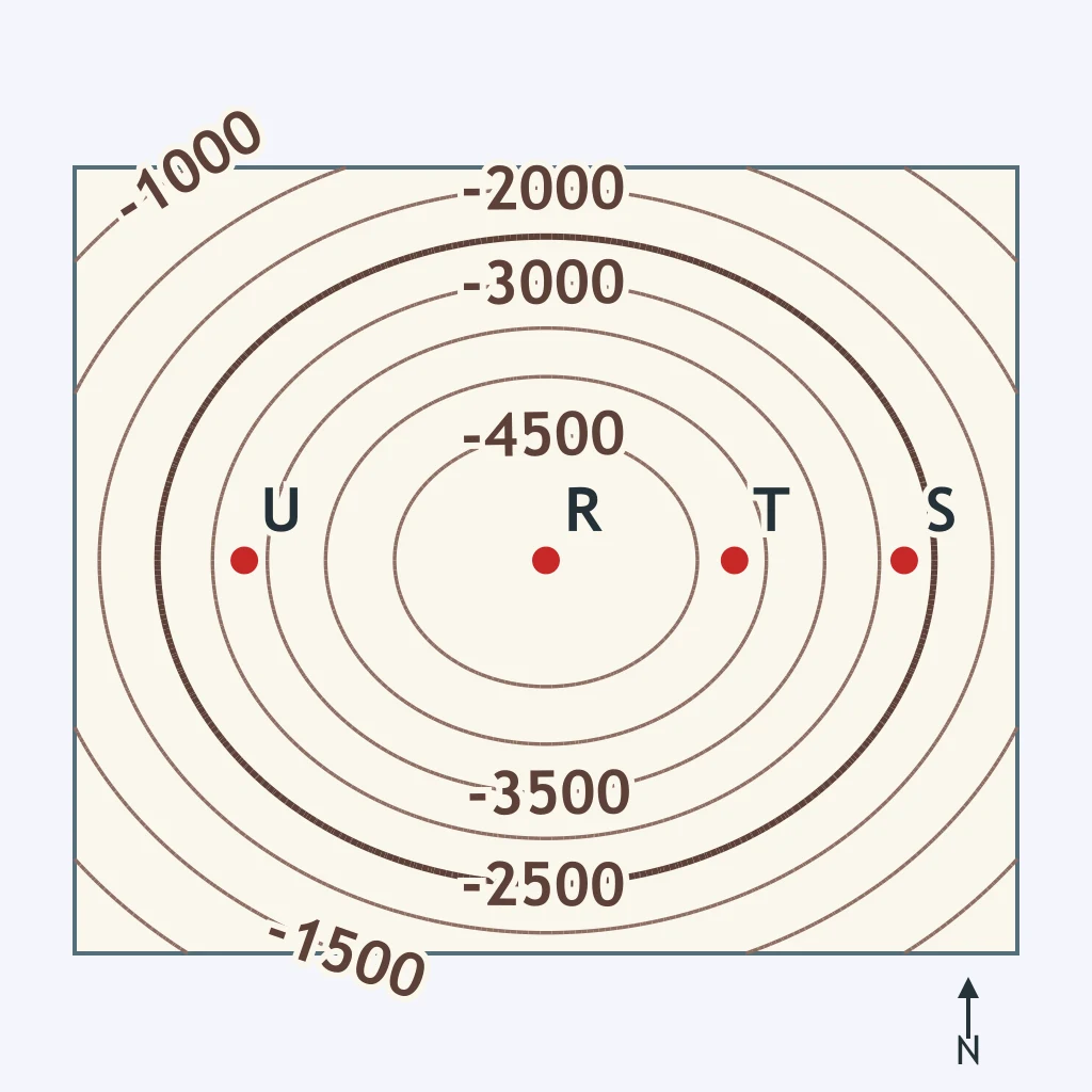
Stations T and U are plotted on the bathymetric map below, contoured every 500 meters. What is the smallest possible depth difference between them?
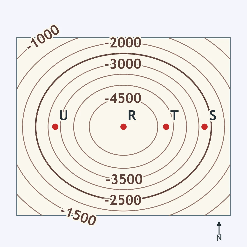
Stations S and T are plotted on the same bathymetric map below. What is the smallest possible depth difference between them?
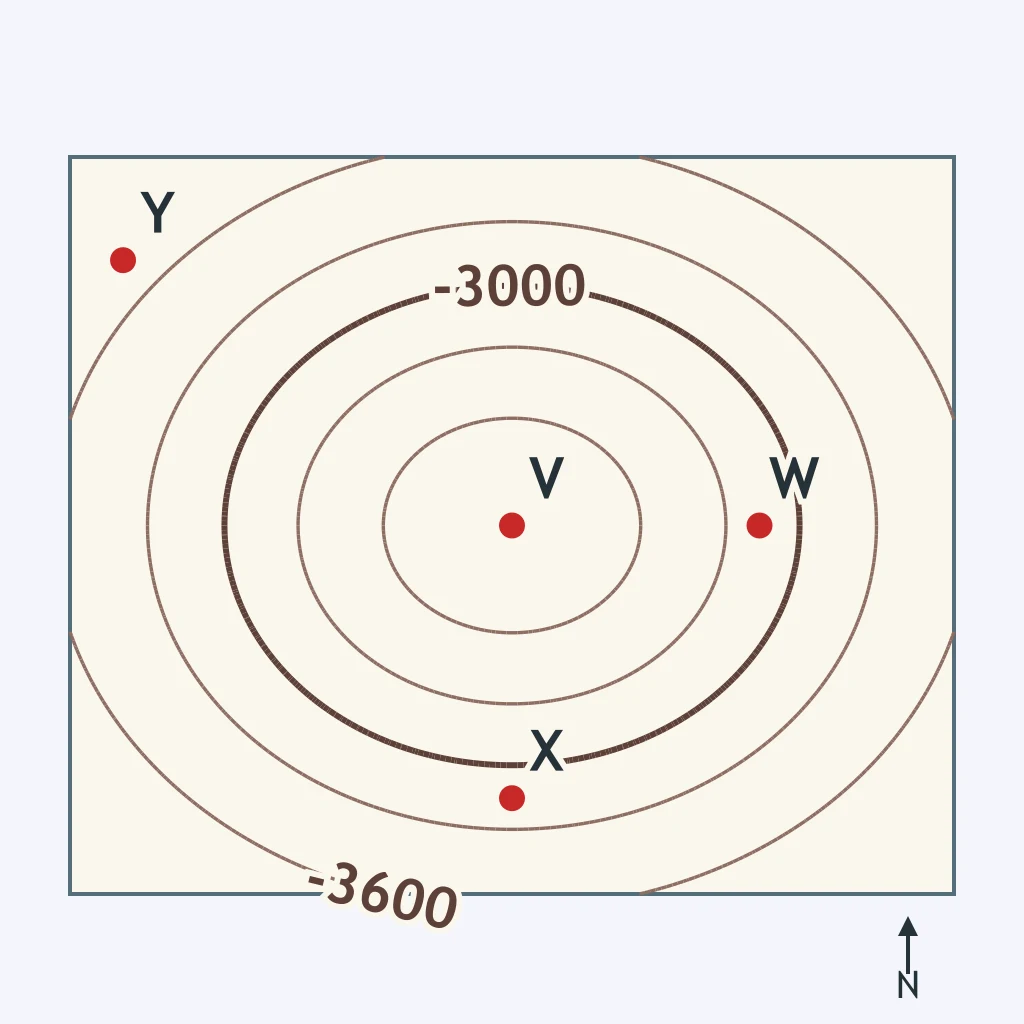
The bathymetric map below is contoured every 300 meters around a mid-ocean ridge crest. Which of the four labeled stations sits at the shallowest depth?
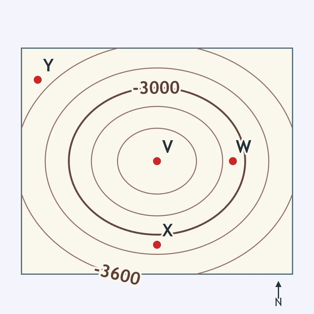
Using the same contoured bathymetric map below, which of the four labeled stations sits at the greatest depth?
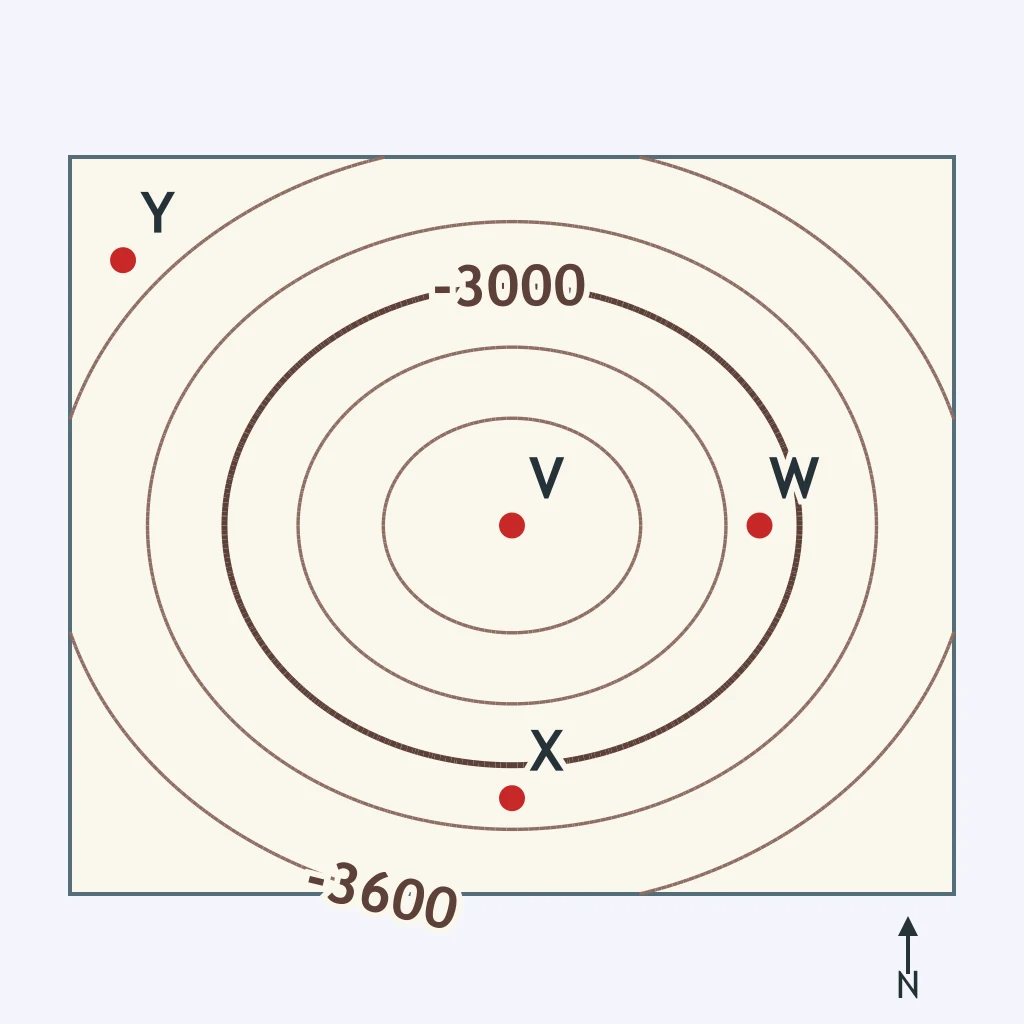
Stations V and W are plotted on the bathymetric map below, contoured every 300 meters. What is the smallest possible depth difference between them?
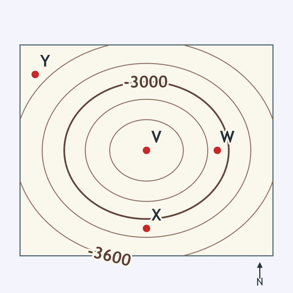
Stations V and X are plotted on the same bathymetric map below. What is the smallest possible depth difference between them?
Compare point A and point C in the cross section below. Which statement correctly contrasts the ocean crust at the two places?
A geologist samples the sea floor at the crest of the Mid-Atlantic Ridge and again on the abyssal plain 1,200 kilometers to the west. Which statement correctly contrasts the crust at the two sites?
A drill core is taken from the floor of the abyssal plain, and a second core is taken from bedrock beneath a coastal state's mountains. Which statement correctly contrasts the two types of crust?
A ship measures water depth at the floor of a deep-sea trench and again on the nearby abyssal plain. Which statement correctly contrasts the two sites?
A sample of sea floor sediment is taken from the continental shelf near a river mouth, and another is taken from the deep abyssal plain far offshore. Which statement correctly contrasts the sediment at the two sites?
A seismic survey measures crust thickness directly beneath a large seamount and again on the surrounding abyssal plain a few kilometers away. Which statement correctly contrasts the crust at the two places?
Crack the passcode before the zombies get in.
Answer, then swat bugs for bonus points.
Race through questions at your own speed.
Same question on every screen. Fastest wins.

Pick a tile, answer, hit bonuses and steals.
Ocean Currents
40 questions